GarMultiRisk: Strengthening Resilience in La Garrotxa Against Natural Hazards and Climate Change
-
Image
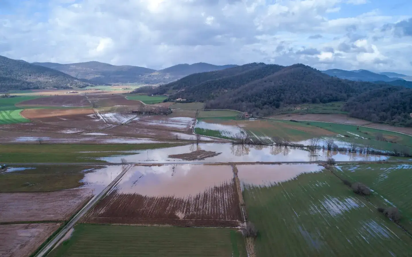
Flood caused by Storm Glòria in La Garrotxa. Source: Marc Planagumà. -
Image
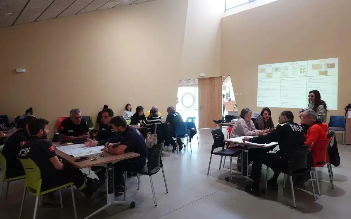
Training workshop for technical and emergency personnel in the region to understand their needs regarding natural risk management and to provide a better final product from the project. Source: Iris Schneider Pérez
The project, promoted by the Centre per a la Sostenibilitat Territorial (CST), aims to develop a management and risk reduction plan for natural hazards in the region to decrease its vulnerability.
In recent years, the increase in extreme meteorological phenomena—such as torrential rains, floods, and wildfires, among others—has highlighted the vulnerability of territories. Without proper planning and an action plan for these events, it is well known that the consequences can be catastrophic. Unfortunately, one does not have to look far to see examples: the DANA that wreaked havoc in Valencia is a clear case. This context, exacerbated by climate change, calls for a risk and hazard management approach that goes beyond isolated and uncoordinated responses.
This is precisely what GarMultiRisk aims to do: anticipate, mitigate, and control—as much as possible and through a combination of historical analysis and data science—the effects of natural hazards, focusing on the long term and promoting a coordinated and proactive response.
"We focus on long-term planning so that when a specific event occurs, we can apply short-term measures and have a clear picture of how and where a hazard could impact the most, as well as knowing exactly where to act at the moment it is happening," explains Iris Schneider Pérez, a researcher on the project, to Xarxanet.
The project is being developed by the Centre per a la Sostenibilitat Territorial (CST), while the scientific aspect is handled by the Natural Risks Assessment and Management Service (NRAMS) of the Institute of Environmental Diagnosis and Water Studies (IDAEA) of the CSIC in Barcelona. The initiative is supported by the Fundación Biodiversidad of the Ministerio para la Transición Ecológica y el Reto Demográfico.
A multirisk approach to reduce the territory’s vulnerability
Initially, GarMultiRisk has focused on compiling a database of natural hazards that have affected La Garrotxa—including wildfires, landslides, ground subsidence, earthquakes, and volcanic activity, among others—over the past 123 years.
This research involved reviewing historical documentary sources such as local press, collaborating with local community members through citizen science events, consulting pre-existing databases, and making direct requests to organizations like the Agència Catalana de l'Aigua (ACA), among others. "Once the data is collected, the interesting part is applying data science using algorithms and machine learning techniques to determine what interrelationships may exist between these different hazards," Schneider points out.
Analyzing the interaction between phenomena is one of the project's cornerstones. This is the multirisk approach—also known as the cascading effect—which explores the idea that one hazard can trigger another or at least increase its likelihood.
"If it starts to rain heavily one day and the falling water fills the rivers, they could overflow and cause flooding; at the same time, erosion along the riverbanks due to water flow could ultimately lead to landslides," illustrates the project technician, who believes that this multirisk approach "will have to start being incorporated into risk and hazard management."
Thus, the idea is to stop studying these natural risks separately and understand how they relate to each other in order to mitigate and reduce their effects.
A Specific Risk Reduction and Management Plan for the Region
Beyond data collection, the final product delivered by the GarMultiRisk project—encompassing much of the work done—is a risk management and reduction plan for the region of La Garrotxa.
This plan will include hazard maps for each identified risk, possible scenario models to anticipate future events, risk monitoring programs, analyses of the physical and structural vulnerability of the territory to the studied hazards, and the development of scientific and educational programs.
With a clear goal of being a useful tool, this risk reduction and management plan has also been designed considering the opinions and needs expressed by environmental technicians, emergency response teams, and political representatives. "We have held meetings with these professional groups to understand their real needs and what might be useful for their work, although it is true that applied science has limitations and does not always achieve everything they would like," says Schneider.
GarMultiRisk focuses on La Garrotxa as a pilot area, but the initiative aims to be replicable in other territories. However, this replicability must take into account the specific characteristics of each environment, as hazards vary depending on the area, as well as the sociocultural variables that influence risk perception.
The value of a territory like la Garrotxa
At this point, one might ask: why was La Garrotxa chosen as the project's pilot area? Is the region more vulnerable to natural hazards than other territories? According to Iris Schneider, the project focuses on La Garrotxa as a pilot area mainly because the scientific team working on it has extensive knowledge of the region due to previous research on volcanoes and other natural hazards.
Additionally, La Garrotxa is a mountainous region with a high population density; in fact, it is the only mountain county in Catalonia with more than 20,000 inhabitants. This makes it a highly interesting context for studying climate change-related risks, such as floods and wildfires.
Moreover, La Garrotxa has a population distribution similar, on a smaller scale, to that of Catalonia: although the population is spread across multiple municipalities, Olot concentrates more than half of the inhabitants. This structure is an important factor in assessing the territory's vulnerability. "Therefore, this does not mean that La Garrotxa is more exposed to hazards, but that its characteristics make it particularly interesting for analysis," notes the project technician.
Regarding the hazards that could most affect the region, similar to other mountainous areas and considering the current climate change context, La Garrotxa is affected by hazards related to meteorological phenomena such as storms and floods, which can lead to landslides and mass ground movements.
As for earthquakes, they do occur, but due to the geological characteristics of the area, they are of very low magnitude. Regarding volcanoes, no imminent activity is expected. On the other hand, wildfires, though mostly caused by human activity, should also be considered natural hazards, as they are strongly linked to atmospheric conditions and may intensify in the coming years.
Thus, all the work carried out by the GarMultiRisk scientific team aims to apply the multirisk approach and deepen risk management to analyze the natural hazards of the region, study their frequency, and integrate all the information into a specific natural risk reduction and management plan for La Garrotxa.
The project will conclude next May, but the scientific team behind it, continuing along this same line of work, aims to build a digital platform that compiles knowledge and studies on multiple natural hazards, making it accessible to environmental technicians in various regions to strengthen territorial resilience against natural hazards and improve adaptability to the changing climate context.


Add new comment